
Bioenergy potential in Lääne county using “Viva Grass BioEnergy”
The context: Lääne County
Lääne County in Estonia is characterized by the high share of semi-natural grasslands, specifically coastal and alluvial meadows. These grasslands are well known as biodiversity hotspots and key stopover locations for thousands of migrating birds. Many of these valuable grasslands are managed using the Common Agricultural Policy (CAP) support, but a large share of the cut grass is not used for animal feeding and remains wasted on the field.
However, grasslands have a potential for energy production as solid biomass heating fuels. Whether grasslands are specifically cultivated for this purpose, or the grass mown from permanent and semi-natural meadows is used, grass can be burnt in co-fired plants for heat generation. In many cases, the use of grass bales for heating is a feasible alternative to regular biomass-based resources such as woodchips.
In an area like Lääne County, energy obtained from semi-natural meadows and reedbeds could be a feasible alternative to traditional fuels in the district heating network. However, a number of questions arise when scoping out the possibilities of using grass biomass resources for heat generation:
– What type of grasslands can be found in Lääne County and where are they located? What is their extent?
– What is the average biomass productivity of semi-natural grasslands in Lääne County?
– What is the bio energy potential, if any, in those grasslands?
– What are the demands for district heating within Lääne County?
What can “Viva Grass Tool” do for you?
The “Viva Grass BioEnergy” module provides answers to this questions through its different sections. It is important to keep in mind that the “Viva Grass BioEnergy”” module supports the initial stages of planning for grass for energy production.
More specifically, “Viva Grass BioEnergy” will provide the following information:
- Assessing grass-based energy resources (area, production, calorific potential for district heating).
- Informing relevant planners/stakeholders about areas with the highest potential for grass for energy (prioritizing).
Bioenergy potential in Lääne County: What? Where? How much?
Before considering the option for using biomass from semi-natural grasslands for district heating, it is necessary to consider the demand:
Where is the consumption of district heating geographically located?
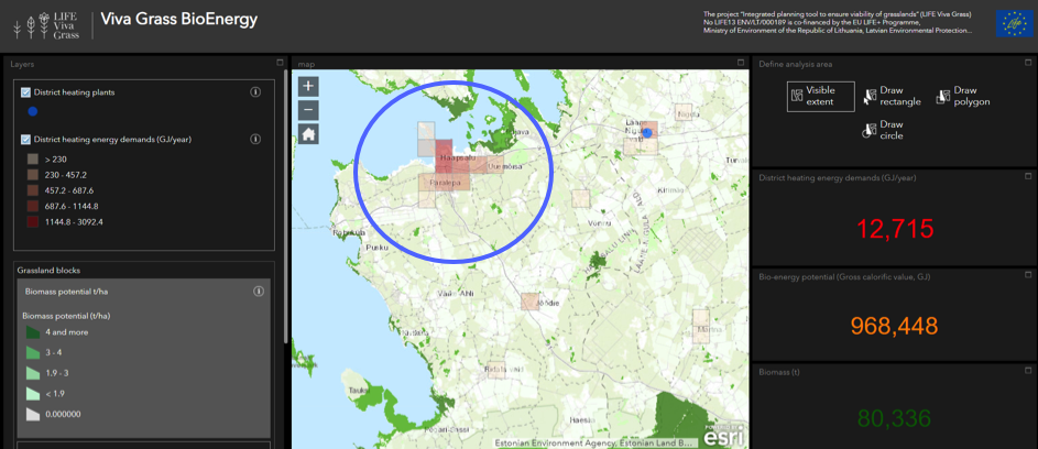
The “Viva Grass BioEnergy” module allows to geographically locate demands for district heating based on a 1 km grid. The demands are understood as the average district heating consumption within a specific grid square, based on the number of flats. In order to visualize the demand;
- Turn on the demand layer on the layers panel on the left.
- Zoom into the area of interest.
- A quick look will already give a hint on where are the areas with the highest potential demand for bioenergy.
How big is that consumption in a year?
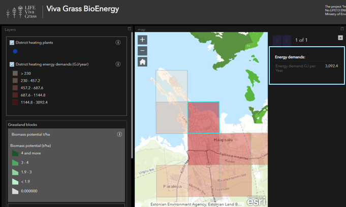
There are two ways to query more detailed information on the district heating demand. Any grid square can be selected with a mouse click and detailed information about consumption within that square will be displayed:
- Zoom into the area of interest.
- Left-click a grid square.
- A panel with the estimated district heating consumed within that grid squared is displayed.
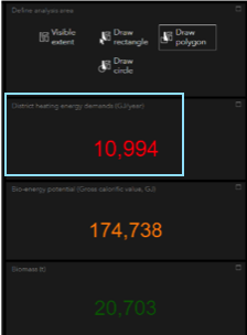
For larger areas, the summary tools in the right-hand panel can be used. The summary tools will provide aggregated information on demands within a user-defined area.
- Zoom to your area of interest.
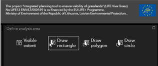
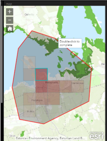
- The selection and summary section is located on the right side of the screen. You can choose your selection method on the define analysis area. By default, the DMS selects the area within the visible extent, but you can also choose draw rectangle, draw polygon and draw circle.Select draw polygon.
- Draw a polygon by clicking around your area of interest.
- Double click to finish your selection.
- Once the selection is completed, the summary information corresponding to the selected are will be displayed on the right panel.
- In order to delete the selection polygon, click in draw polygon.
Where are the grasslands located in Lääne County?
What are the patterns of semi-natural grasslands distribution in Lääne County?
What type of semi-natural grasslands occur in Lääne County?
Once the potential demands for district heating have been assessed, it is useful to explore the distribution, area and types of grasslands in Lääne County, in order to obtain a general overview of the potential supply of grass for energy. In the “Viva Grass BioEnergy” the user can gather general information on grassland types, potential biomass production and potential calorific power by visualizing the layers in the map in the center of the tool. In order to retrieve information on grassland types and distribution:
- Zoom to the area of interest.
- Use the layer switching pane on the left side to select what kind of information you want to display in the map.
- Select thelanduselayer to be displayed on the map.
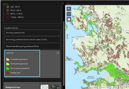
Most of the semi-natural grasslands are distributed along the coast and riverbeds. However, at this level of detail we do not know exactly what type of semi-natural grasslands are located where, and what ecosystem services do they provide. For more detailed information, the user can consult each grassland individually:
- Zoom to the a grassland field.
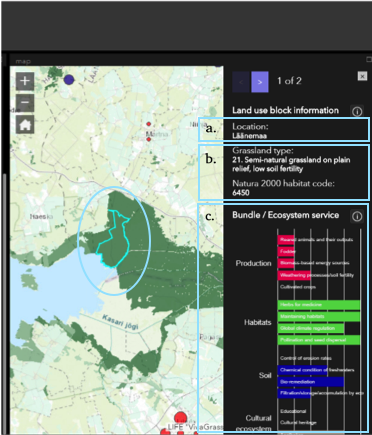
- Left click on the grassland with the mouse and an information pane will be displayed to the right of the map.
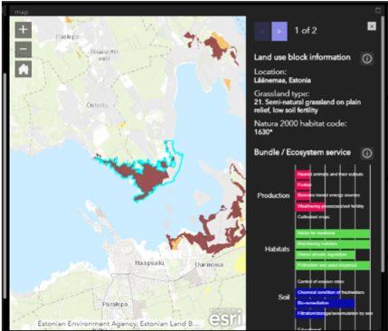
- On the information panel you can consult several layers on information, organized in two sections. In section 1:
- Location of the grassland.
- Grassland type and semi-natural grassland type according to the Annex I of the Habitats Directive categories.
- Information on the ecosystem services and bundles of ecosystem services provided by that particular grassland.
What is the productivity of semi-natural grasslands?
What is the potential production of energy from semi-natural grasslands?
Among the wide range of ecosystem services provided by semi-natural grasslands, biomass-based energy sources directly represent the potential of grasslands to be used as energy sources. Additionally, it is tightly related to the habitats bundle of ecosystem services, since the adequate management of semi-natural grasslands (e.g. cutting the grass for energy production) fosters the maintenance of habitats and other biodiversity-related ecosystem services.
With the “Viva Grass BioEnergy” functionalities, we have so far assessed the demands and the grassland types in Lääne County, but the key element of the assessment is the potential productivity of different grassland types and bioenergy potential in terms of calorific value. Both these values are provided in biophysical units in the “Viva Grass BioEnergy” module. Biomass potential is understood as the yield of herbaceous biomass measured as dry weight. Each semi-natural grassland type is assigned a unique value of average biomass potential after sampling several grasslands throughout Estonia. Similarly, each semi-natural grassland type is assigned a unique value of average bioenergy potential, which is calculated based in the calorific valueof total biomass and the dry weight of different functional groups in semi-natural grassland types. The bioenergy potential of grasslands is then understood as the potential for energy production through combustion.
The user can gather general information on potential biomass production and potential calorific power by visualizing the layers in the map in the center of the tool:
- Zoom to the area of interest.
- Use the layer switching pane on the left side to select what kind of information you want to display in the map.
- Select the biomass potential or bioenergy potential layer to be displayed on the map.
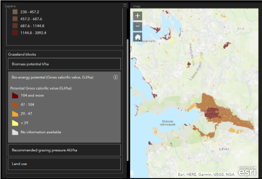
The map visualization already provides an overview of hotspots of bio energy potential, but for more detailed information, the user can click on specific grasslands and consult the display panels:
- Zoom to the a grassland field.
- Left click on the grassland with the mouse and an information pane will be displayed to the right of the map.
In section 2 of the information panel you can consult information related to the bio-energy potential and the current management status:
- Biomass production potential.
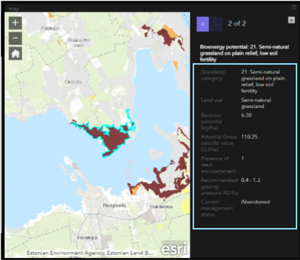
- Calorific value potential.
- Presence of reed encroachment.
- Recommended grazing pressure.
- Current management regime.
From a regional planning perspective, it is useful to obtain summary data for a certain area. To do this, use the selection and summary tools in the right-hand panel:
- Zoom to your area of interest.

- The selection and summary section is located on the right side of the screen. You can choose your selection method on the define analysis area. By default, the DMS selects the area within the visible extent, but you can also choose draw rectangle, draw polygon and draw circle.Select draw polygon.
- Draw a polygon by clicking around your area of interest.
- Double click to finish your selection.
- Once the selection is completed, the summary information corresponding to the selected are will be displayed on the right panel.
- In order to delete the selection polygon, click in draw polygon