Hogweed management using “Viva Grass Planner”
Hogweed DMS story
- Hogweed (Heracleum sosnowskyi) is common invasive species in Baltic region – once introduced as fodder crop by Khruschev’s agricultural modernisation programme now it have become widespread and hard-to-eradicate weed bearing serious injury risks if contacted.
- Eradication of hogweed is obligation of the land owners, local municipalities and State Plant Protection Service is controlling this process.
- All hogweed plots should be removed, but depending on different conditions hogweed removal methods can differ. The task is to classify land use blocks to according to identified conditions. Every defined class will present different removal method.
- It is very important to control hogweed removal process. Land owners can get fines if not to remove hogweed. However, it is possible to prioritize hogweed polygons and land use blocks in which these polygons are, according to a higher risk of spreading of hogweed (ex. Hogweeds close to rivers, roads can spread faster). This prioritization shows which land use blocks with hogweed are more important to be check if owner removed hogweed.
- Visual analysis of hogweed distribution, removal progress and possibility to see all this in spatial context can help identify additional relations, method efficiency, etc.
The role of Viva Grass Planner in this DMS
To this DMS related stakeholders:
- Local scale: Municipalities controlling and planning hogweed eradication in-situ;
- Local scale: Land owners planning eradication;
- Regional scale: State Plant Protection Service controlling and planning hogweed eradication
Viva Grass Planner functionality important for this DMS:
-
- Org. account. Every organization gets their own part of the cloud based system. This part can be managed and customized by organization’s administrator/user and adopted to their needs. An organization can have and manage different territory. It can be whole country, municipality, protected area or even farm. Organization’s data is not available for other Planner users in any form.
- Data from basemap + VG context data layers. During the Viva Grass project a lot of methodologies and data sets were developed. Some dataset structure and prepared data can be re-used by organization to speed organization’s Viva Grass Planner account preparation and to be able to start data assessment or other spatial data based decision making faster.
Context data layers provided by Viva Grass enables the organization to have important spatial context without the need to search for the available data, without integration to the Tool, etc. - Org.’s context data layers. It is a list of identified and pre-configured context data layers. Every organization can use this structure to upload or to enter their own contextual data and to use it for the calculations (intersection), context data storage and management. More than 10 thematic layers and their structures are provided. Three additional custom context data layers for point, line and polygon features are available too. These custom layers can be used to upload and use for any type of context data.
- Custom attributes. For the different needs of every organization it is possible to add custom attributes to the land use block polygons. The formats or the attributes can be text, double, integer. Attributes can be used to store temporary or permanent information about land use blocks, can be used to store calculation, prioritization results, etc.
-
- Functionality:
- Visual analysis/assessment. Viva Grass Planner provides a wide range of map functionality: basemap selector, 3rd party data upload, zoom in/zoom out, location search, map layer management including possibility to change layer transparency, etc. All this enables the user to assess map data visually and to make spatial data based decisions.
- Functionality:
- Calculation. It is one of the most powerful tools in Viva Grass Planner. This simple to use tool enables the user to intersect land use blocks with a selected context data layer and to store this intersection result as attribute info in the land use block. For this DMS it is used to select land use blocks which are close to riverbeds, close to roads, identify which land use blocks has hogweed infected areas, are in the aesthetically important area, etc.
- Classification. This functionality enables the user to classify land use blocks to different categories based on advanced selection expressions related to the land use block attribute information. For this DMS it will be used to classify hogweed infected land use blocks by possible and recommended hogweed removal methods.
- Prioritization. This tool will be used to prioritize hogweed removal control activities. According to selected land use block attributes we will be able to provide importance of each attribute and finally we will get a priority rank. This will provide suggestion for the controlling institution in which order land use blocks should be visited to get the most efficient control results.
- Upload/Download. This is very important functionality of the Tool, because you can download the data you need in any step, you can modify it in other (eg. ArcGIS for Desktop) tools and upload it back to the Viva Grass Planner module.
Adding context data layers
Viva Grass Planner >> More >> Settings >> Layers settings
Turn on layers listed below by checking checkboxes.

Context data layer list:
- Rivers (lines) – will be used to intersect (with 100 m. buffer) with land use blocks to get land use blocks which are close to the riverbeds.
- Roads (lines) – will be used to intersect (with 100 m. buffer) with land use blocks to get land use blocks which are close to the roads.
- Risk of abandonment (polygons) – will be used to intersect with land use blocks to get land use blocks which are (or intersects with) in zones with a high risk of abandonment.
- Invasive species polygons (hogweed) (polygons) – will be used to intersect with land use blocks to get land use blocks which are infected (has hogweeds) by hogweeds.
- Custom Polygon Layer (polygons) – aesthetically important areas in Cesis municipality – will be used to intersect with land use blocks to get land use blocks which are (or intersects with) in aesthetically important zones.
Other context layers can be switched on or off if needed.
Important! To see changes user needs to reload Tool and login once again.
Adding custom attributes
Viva Grass Planner >> More >> Settings >> User attributes
Add additional, custom attributes for the Land use blocks. These attributes can be used to store additional data about land use blocks, to store calculation, intersection, classification or prioritization results, etc.

| ua5 | HighAbandRisk | Double |
| ua6 | ImportantAestheticly | Double |
| ua1 | HasHgw | Double |
| ua2 | HgwPolygonSize | Double |
| ua3 | CloseToRiver | Double |
| ua4 | CloseToRoad | Double |
For this DMS we will need such custom attributes:
- HasHgw (Double) – to store info if Land use block intersects with hogweed polygons
- HgwPolygonSize (Double) – to store size of the hogweed polygons which intersects land use block
- CloseToRiver (Double) – attribute to store info if land use block is close to river (100 m. buffer)
- CloseToRoad (Double) – attribute to store info if land use block is close to main roads (100 m. buffer)
- HighAbandRisk (Double) – attribute to store info if land use block intersects with polygons of high risk of abandonment.
- ImportantAestheticly (Double) – attribute to store info if land use block intersects with polygons of important areas of aesthetic importance.
Other attributes can be added if needed.
Important! To see changes user needs to reload Tool and login once again.

Additional attribute calculation
Viva Grass >> Calculation
Attribute calculation can be done in ArcGIS for Desktop or in the Planner. This tool lets intersect two layers (land use blocks and selected org’s contextual layer), intersect with a defined buffer (around land use block), find land use blocks which are within org’s contextual data layer polygons and how much elements from org’s context data layer land use block contains.
- Land use blocks with hogweed
In this step land use blocks which intersects with known (org’s context data layer “Invasive species polygons”) hogweed polygons. As the result we get list of land use blocks with hogweeds.
Count of hogweed polygons (which intersects with land use block) is stored in “Summarize to field” (in this case “HasHgw”) field.

“HasHgw” > 0 means land use block has hogweeds.
Calculation results can be checked by filtering attribute table data (HasHgw > 0):

- Hogweed polygon size which intersects land use block
In this step the size of the hogweed territory (which intersects with relevant land use block. But not necessary is within land use block) is stored.

- Land use block close to river (100 m.)

- Land use block close to road (100 m.)

- Land use blocks in high risk of abandonment zones

- Land use blocks located in aesthetically important zones
Aesthetic important zones were uploaded to the custom polygon layer. In this step we will calculate and define which land use blocks are in these territories and are important aesthetically.

Important! Hogweed related attributes are calculated and stored into the structure of the Viva Grass Planner database. Now these values, together with other land use block attributes, such as land use type, land use, land quality, slope, ES values, bundles, trade-offs, etc. can be used for classification, prioritization and visual analysis.
Classification by Hogweed removal method
All hogweed plots should be removed, but depending on different agro-ecological and geographical conditions hogweed removal methods can differ. The task is to classify hogweed invaded fields according to identified conditions. Every defined class will present different removal method. This classification is based not on a single attribute, but on the set of them:
Demo steps:
- Filter land use blocks which has hogweeds (Attribute filtering “HasHwg > 0”)

- Open classification Tool (Viva Grass Planner >> classification)
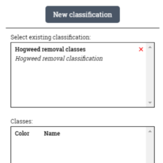
- You can create a new classification rule by pressing “New classification” button or use and existing saved rule if you have one by selecting it from the “Select existing classification:” panel and pressing “Open”.

- Opening the classification. In this example we use the existing rule.
- Editing or creating classes. You can edit the existing or create new classes within the rule. This is done by manually writing the expression and validating it by pressing the “Test” button.

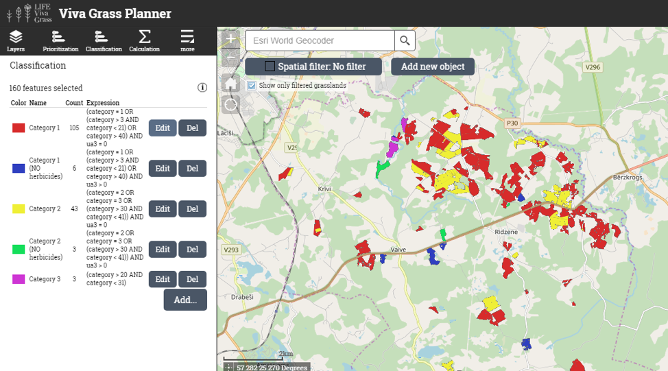
- Classification result appears in map layer list

Below in the table you see classes stored in the classification rule “Hogweed removal classes”. The expression in class “category 1” is explained like this:
Category = 1 means we select polygons which are Land use type = Cultivated grassland on plain relief, low land quality also Category > 3 AND category < 21 which means we select all the land use types from 3 to 20 and also land use types which are over Category > 40. All these land use types also need to be ua3 = 0, which mean they are close to a river. To eradicate the hogweed in these polygons 4 methods are recommended. Other classes can also be described in this way.
| Class name | Expression | Recommended method |
| Category 1 | (category = 1 OR (category > 3 AND category < 21) OR category > 40) AND ua3 = 0 | Grazing
Mowing Combined Herbicide |
| Category 1 (NO herbicides)* | (category = 1 OR (category > 3 AND category < 21) OR category > 40) AND ua3 > 0 | Grazing
Mowing Combined |
| Category 2 | (category = 2 OR category = 3 OR (category > 30 AND category < 41)) AND ua3 = 0 | Grazing
Mowing Ploughing Combined Herbicide |
| Category 2 (NO herbicides)* | (category = 2 OR category = 3 OR (category > 30 AND category < 41)) AND ua3 > 0 | Grazing
Mowing Ploughing Combined |
| Category 3 | (category > 20 AND category < 31) | Grazing
Mowing |
* Herbicides usage restrictions: near settlements, near semi-natural grasslands, near streams.

Prioritization of hogweed removal control activities
It is very important to control hogweed removal process. Once removed hogweed has very high potential to germinate and spread seeds in very short time, thus fields where eradication was done should be constantly surveyed. Land owners can get fines if not to remove hogweed. However, it is possible to prioritize hogweed polygons and land use blocks in which these polygons are, according to a higher risk of spreading of hogweed (ex. Hogweeds close to rivers, roads can spread faster). This prioritization can show which land use blocks with hogweed needs to be check if owner removed hogweed.
Demo steps:
- Filter land use blocks which has hogweeds (Attribute filtering “HasHwg > 0”)

- Open classification Tool (Viva Grass Planner >> Prioritization)
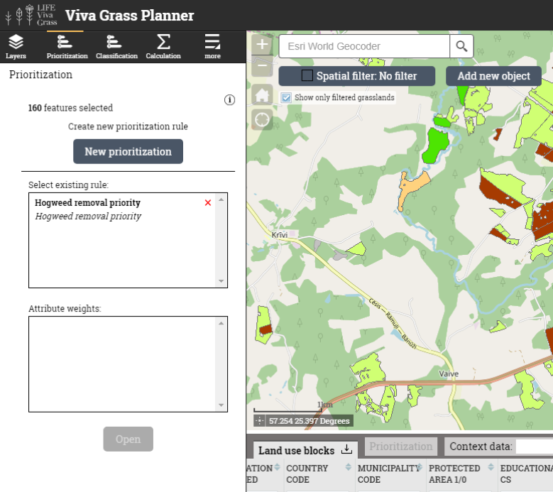
- You can create a new prioritization rule by pressing “New prioritization” button or use and existing saved rule if you have one by selecting it from the “Select existing rule:” panel and pressing “Open”.

- Opening prioritization rule

- Editing prioritization rule. You can edit the prioritization rule. This can be done by selecting new attributes for the prioritization and changing their weights.
- Change attribute list (“Edit attribute list”)

- Change weights

- Store index to field. You can also store the calculated prioritization index in one of your empty custom attributes and run another prioritization rule on the same area to compare the results.

- Save as a new rule

- Update existing
- Save as new
- Priority index value visualization

- Change attribute list (“Edit attribute list”)
- Prioritization result appears in map layer list
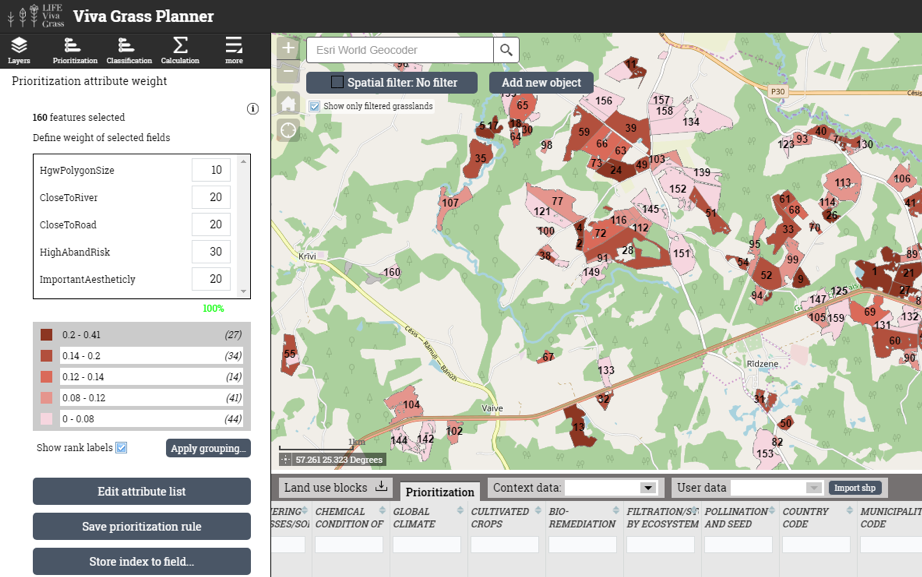
Prioritization rule weight explanation:
| Attribute | Weight | Comments |
| HgwPolygonSize | 10 | Though existing hogweed area size is important, it is not as important as other factors, therefore it has a lower weight. |
| CloseToRiver | 20 | Hogweed seeds spread rapidly to new places by river flowing water, so it is important to give a high weight for areas near the rivers. |
| CloseToRoad | 20 | Hogweed seeds spread rapidly to new places by winds created by mowing cars, so it is important to give a high weight for areas near the roads. |
| HighAbandRisk | 30 | Lands which are abandoned or have a high risk to be abandoned are the perfect areas for hogweed to spread, therefore these areas are the most important to monitor and have the highest weight. |
| ImportantAestethically | 20 | We don’t want the aesthetically important areas to be invaded by hogweed, therefore it gets a high weight. |