
5. Ecosystem service concept in policy and land use management
Nowadays ecosystem services are acknowledged as an important concept for policy and decision making, because of its holistic view on interactions between nature and humans and potential to address conflicts and synergies between environmental and socio-economic goals. First, policy makers have realised that ecosystem services or nature based solutions (e.g. using wetlands for water purification or flood prevention) might be more cost efficient than technical infrastructures (Maes et al., 2012).Moreover, ES concept can provide a comprehensive framework for trade-off analysis addressing compromises between competing land uses and help to facilitate planning and development decisions across sectors, scales and administrative boundaries (Fürst et al. 2017).
5.1. Contribution of the ecosystem services concept to different policy sectors
The interest of policy makers in the concept of ecosystem services arose, when it was clear that the global target to prevent the loss of biodiversity by 2010 has not been met. Thus it was first applied for strengthening nature conservation policy in frame of the Convention on Biological Diversity and the EU Biodiversity strategy 2020. However, as proposed by the European Commission, mapping and assessment of ES, required by the Action 5 of the EU Biodiversity Strategy 2020, is not only important for advancement of biodiversity objectives, but has strongly related with implementation of other related policies, including water, marine, climate, agriculture, forestry as well as regional development (Maes et al, 2014; Burkhard B. and Maes J. (Eds.), 2017) (Fig. 5.1). Ecosystem service mapping and assessment results can support sustainable management of natural resources, to be applied in development of nature-based solutions, contribute to spatial panning as well as environmental education.
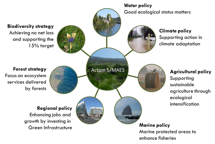
Figure 5.1. Applying of the EU Biodiversity Strategy 2020 Action 5 outputs in different policy sectors (Source: Maes et al., 2014).
5.1.1. Nature conservation and biodiversity policy
The ecosystem services were first introduced into the international policy for protection of biodiversity in 2010 at the tenth meeting of the Conference of Parties to the Convention on Biological Diversity (CBD), where the global Strategic Plan for biodiversity for the period 2011–2020 was adopted. The Plan includes so called “Aichi targets”, which besides traditional conservation-based biodiversity targets aims to enhance benefits to people from biodiversity and ecosystem services. It was followed by adoption of the EU Biodiversity Strategy 2020, which set the goal to maintaining and restoring ecosystems and their services and included mapping and assessment of ecosystem services as one of 20 actions to be implemented by the EU member States. EU supports implementation of this policy through its framework programme for research (Horizon 2020) as well as the other financial instruments, e.g. LIFE+ programme.
The process of Mapping and Assessment of Ecosystems and their Services (MAES) first of all contributes to the knowledge on the status and trends of ecosystems and related services as well as helps to target measures for ecosystem restoration and management. ES mapping results can be applied in assessment and planning of protected area/ green network. Furthermore, MAES outputs demonstrates the contribution of ecosystems and biodiversity to human well-being, which helps to justify the importance of nature conservation measures to society.
5.1.2. Environmental policy
Ecosystem service mapping and assessment results can contribute to environmental policy in relation to assessment of risks and impacts to ecosystem or human health from different human activities as well planning various mitigation or management measures.
In particular, ecosystem services are directly engaged in the following environmental policy issues (Maes et al, 2014):
- Water policy: Implementation of the EU legislation for management of water resources (e.g. the Water Framework Directive, the Groundwater Directive) requires high quality and comprehensive information on the quality and quantity of freshwater resources. The outputs from the MEAS process will complement the available information and facilitate more efficient protection and management. For example, mapping of nutrient retention and maintenance of chemical condition of freshwater provide direct input to river basin management plans. Furthermore, MAES process helps to integrate this information into wider assessment of ecosystem conditions.
- Climate policy: Ecosystems play important role in carbon sequestration and consequently in mitigating climate change as well as in adapting to its impacts. Therefore the recent communication in the climate change adaptation policy puts considerable emphasis on nature-based solutions. Several regulating ES (e.g. climate regulation, maintenance of hydrological cycle and water flow and control of erosion rates) are essential for planning climate change mitigation and adaptation measures, including reduction of disaster risk related to extreme weather conditions and flood prevention as well as cooling capacity provided by green infrastructure in urban areas. At the same time, the impacts of climate change can be assessed in relation to all categories of ES.
- Marine policy: marine and coastal ecosystems provide essential contributions to human well-being in multiple ways, including food, jobs, security as well as quality of life and possibilities for recreation. The Marine Strategy Framework Directive is the main legal instrument in EU for protecting of marine ecosystem, which sets objective to achieve or maintain good environmental status (GES) of European marine waters by 2020. It requires Member States to assess the status of marine waters as well as to applying ecosystem-based approach to the management of human activities in order to ensure that the collective pressures are kept within levels compatible with the achievement of good environmental status and enables the sustainable use of marine goods and services. Thus data collected for MSFD for assessment of status of marine ecosystem is complementary to MAES process and vice versa, contributing to assessment of impacts of collective pressures and implementation of the Programmes of Measures for achievement of GES.
- Pollution control: Measures for controlling dispersal of pollutants can be based on mapping potential of mediation by biota or ecosystem (e.g. bio-remediation, filtration, sequestration, storage and accumulation) as well as mediation of flows (including water flow maintenance and air ventilation).
5.1.3. Agriculture and rural development policy
Another field with high potential of the ecosystem service concept is agriculture and rural development, involving planning of grassland management practices. Agriculture land as heavily managed ecosystem is directly involved in ecosystem service production (e.g. crops for human consumption, biomass for animal feeding, fertilizers or energy, recreational potential and aesthetic value etc.) as well as depends on ecosystem service supply (e.g. pollination, pest and disease control, maintaining of soil fertility), and at the same time is having direct impact on ecosystem service supply (e.g. maintaining habitats, chemical condition of freshwaters, global climate regulation etc.)(Burkhard B. and Maes J. (Eds.), 2017). Supply of these services directly depends on the management practice. It is assumed that low input (extensive) farming systems usually are more dependent on ecosystem service supply and have less impacts compared to conventional high input (intensive) farming. Supply, impacts and dependencies of different services and their management possibilities also vary depending on scale – for example provisioning services are mostly associated with farm level, while habitat maintenance, recreational potential and aesthetic value, water quality and climate regulation might be more relevant if looking at landscape or regional scale. Thus understanding of ecosystem service flows and their multi-level aspects are crucial for effective management of rural areas and related ecosystem service supply.
Mapping and assessment of agriculture ecosystem services can assist in:
- visualisation of the scale at which different services operate;
- assessing distribution of the ES supply and demand and highlighting dependencies;
- visualisation of positive as well as negative impacts of agriculture practice;
- targeting interventions required to ensure or improve ES supply.
ES mapping and assessment results can also contribute in targeting the rural policy objectives and required measures for improving ES supply and related payment schemes. For example, restoring and preserving ES has been already included as one of the priorities in the rural development pillar of the EU’s Common Agricultural Policy.
5.1.4. Forestry policy
Forest ecosystems are crucial element of landscape and biodiversity and at the same time providing essential contribution to human well-being. While in former times timber production was the main focus in management of forests, the new challenges of the 21stcentury have stimulated a multi-functional approach, involving the delivery of multiple goods and services including climate regulation, erosion control and hydrological regulation (Luque et al. 2017). A new EU Forest Strategy: for forests and the forest-based sector, introduced by the European Commission in September 2013, comes up with a new framework in which forest protection, biodiversity conservation and the sustainable use and delivery of forest ecosystem services are addressed. The strategy promotes a coherent and holistic approach for forest management including: i) the multiple benefits and services of forest; ii) internal and external forest-policy issues and iii) the complete forest value-chain. Thus, mapping and accounting of forest ES provides an integrated and systematic view of the forest systems and the effects of different pressures (Maes at al. 2014).
5.1.5. Regional development policy and spatial planning
Assessment of the ES supply and demand as well as optimising delivery of ES (e.g. by planning and creating of green infrastructure or green network) can contribute significantly to regional and urban development, support decision making on future investments, enhance jobs and economic growth. Furthermore, the use of ES assessment and mapping results in spatial planningprovides greater opportunities to integrate environmental considerations into decisions making on land use change or management (e.g. by introducing it into the Strategic Environmental Assessment process). ES mapping and assessment has already been widely used to support planning and decision making from national to local level in several EU countries. For example, in Finland many regional strategic and local practical plans aim at enhancing, restoring or crating ecosystems and related services. The ES mapping has been also introduced in the ongoing European maritime spatial planning initiatives (e.g. in Latvia and Sweden), in order to assess the use potential as well as possible impacts on marine ecosystem.
The ecosystem service concept also has a great potential to be applied in landscape planning, which aims at enhancing, restoring or creating landscapes and related services. This is demonstrated by the German landscape planning practice, which involves the analysis of the current state of landscape concerning a set of landscape functions and its capacity to fulfil the human demands.
The main inputs of the ecosystem service mapping and assessment to the spatial planning can be summarised as follows (Albert et al., 2017):
- identification of the so-called ecosystem service ‘hotspot’ areas with high potential of ecosystem service supply and/or sensitivity to particular impacts related to planning decision, which might require planning solutions for their safeguarding or restoration;
- assessing the impacts of the planning solutions on ecosystem conditions and service supply (i.e. application within the SEA procedure);
- visualisation of the trade-offs in ecosystem services supply resulting from different lands use alternatives;
- identification of mismatch between areas of ecosystem service supply and demand (when combining the ecosystem service maps with assessment of people’s values and actual use of the services);
- enhancing stakeholders’ and decision-makers’ engagement in the planning process by communicating the overall benefits and shortcomings of the planning proposals;
- enhancing citizens’ participation in the planning and decision making by gathering people’s local knowledge and perceptions and enhancing knowledge exchange on ecosystems and their services.
Nevertheless, it shall be remembered that for successful integration of the ES mapping and assessment in the spatial planning process the given time frame and financial limitations as well as needs and interests of the users and decision makers shall by respected. The degree of ES mapping detail, applied methods and indicators depends upon the planning purpose and statutory requirements of the particular planning instrument. Also, the uncertainties of the assessment results shall be communicated to the decision-makers and public.
5.2. Instruments and methods for applying ecosystem services in decision making
5.2.1. Trend analysis and nature capital accounting
The trend analysis is usually applied in the policy-making process for setting the policy objectives (i.e. targets to be reached) as well as for monitoring of the policy implementation and its impacts. Applying the trend analysis to different components of ecosystems and related services can contribute to understanding of the past and current developments as well as possible future of ecosystems. Thereby the results of trend analysis allow to better design and describe future scenarios of ecosystem development (Guerra et al 2017).
As described before, the ES assessment results and trend analysis can provide essential information on implementation of various EU policies, e.g. in field of nature conservation, climate change, water management, marine protection as well as to assess impacts of policy sectors based on use of ES, e.g. agriculture, forestry, fishery etc. However this requires comparable time series of the ES assessment results, which currently are not available for most of the courtiers.
To facilitate the regular data collection on ES, the EU Biodiversity Strategy within the Action 5 sets a task to assess the economic value of ES and integrate these values into accounting and reporting systems at EU and national level. Therefore, as part of the MAES process, a methodological framework for the Natural Capital Accounting (NCA) has been developed. This involves step-by-step approach, which begins with building of the biophysical foundation for subsequent valuations steps. Such biophysical foundation requires clearly categorized, well-structured as well as spatially explicit input data sets (Maes et al. 2014). The United Nations Statistical Division (UNSD) has set up the System of Environmental-Economic Accounting (SEEA) for collecting internationally comparable statistical data on environment in relation to economy and thus creating a basis for ES accounting system. By now several EU Member States have started the development of their natural capital accounts.
5.2.2. Scenario analysis
A scenario can be defined as a description of possible future situations, including path development leading to that situation. Scenarios are not intended to represent a full description of future, but rather to highlight central elements of possible future and to draw attention to the key factors that will drive future developments. Many scenario analyst, underline that scenarios are hypothetical constructs and do not claim that they represent reality practices (Schoemaker, 1995). Nevertheless, scenarios are often applied as supporting instrument in policy development and decision-making (Schoemaker, 1995; Guerra et al. 2017):
- to generate knowledge about the present and the future and to identify the limits of that knowledge;
- to serve a communicative function, since scenario development is often based on an exchange of ideas between people with different perspectives;
- to aid decision makers in formulation of policy goals;
- to explore implications of alternative development pathways and policy options;
- to examine the potential effectiveness of proposed decision and management practices;
- to support development of adaptive management strategies.
Scenario analysis has been successfully implemented in many local studies as well as national, regional and global assessments for examining how different land use or management option would interact with ecosystem service supply. This includes assessment of the trade-offs in ES supply between different management alternatives as well as comparing the spatial distribution of certain ES bundles (or synergies) and conflicting (or trade-off) areas, where interests in supply of certain ESs would need to be balanced.
Scenario development and analysis includes three major phases (Guerra et al., 2017):
- Initial phase: defining of the major tendencies for a specific region or subject and to analyse the underpinning drivers of change. This phase can result in a few plausible scenarios.
- Second phase: translating of the identified scenarios qualitatively or quantitatively into variables that describe the major drivers of change (e.g. economic development or demography). The drivers of change then can serve as input for models that relate these changes to environmental change, or impacts to biodiversity and ES.
- Third phase: analysis of the outcomes of these models and formulation of policy options to avoid undesired developments.
Depending on policy of decision making context different types of scenarios can be distinguished (IPBES, 2016): i) “exploratory scenarios” represent different plausible futures, often based on storylines, and provide means of dealing with high levels of unpredictability, associated with the future trajectory of many drivers; ii) “ intervention scenarios” evaluate alternative policy or management options – through either “target-seeking” or “policy-screening” analysis (in case of “target-seeking scenarios” alternative pathways are examined for reaching an agreed-upon future target, while in case of “policy-screening scenarios” (also known as “ex-ante scenarios”), various policy options are considered); “retrospective policy evaluation” (also known as “ex-post evaluation”) compares the observed trajectory of a policy implemented in the past to scenarios that would have achieved the intended target.
The IPBES methodological assessment of scenarios and models of biodiversity and ES (2016) illustrates how different types of scenarios and modelling approaches can serve the major phases of the policy cycle, including agenda setting, policy design, policy implementation and policy review (Fig. 5.2).

Figure 5.2. Different types of scenarios and their applicability policy making and implementation. (Source: IPBES, 2016).
For example, “exploratory scenarios” can contribute to problem identification and agenda setting, while “intervention scenarios”, which evaluate alternative policy of management options, can contribute to policy design and implementations. IPBES assessment states that exploratory scenarios are most widely used in assessments on the global, regional and national scales while intervention scenarios are usually applied in the decision-making on national and local scales.
5.2.3. Impact assessment
Impact assessment aims to identify the future consequences of proposed actions in order to support decision-making. ES mapping and assessment results can be integrated within different impact assessment procedures (e.g. Strategic Environmental Assessment of planning documents as well as in the Environmental Impact assessment of development projects), thus extending the scope of impact assessment from purely environmental considerations to other dimensions of human well-being.
ES can be related to various stages of the impact assessment (Geneletti &Mandle, 2017), including:
- Scoping and baseline analysis:ES mapping results can be used for selection the priority ES that are most relevant for the action under analysis (i.e. services on which action depends as well as services it affects). This stage also requires understanding of the spatial relationship between the area affected by the action, the area where ES are produced and the area where they are used.
- Consultations:ES maps helps in focusing debate and engagement of stakeholders, including also participatory mapping exercise to understand how ES are perceived and valued by different beneficiary groups. Results of consultation phase can be used in development of alternatives, identification of “no-go” areas for specific activities or suggesting priority locations.
- Assessing impacts of development alternatives:spatial analysis of ES supply allows tracking impacts to specific beneficiaries and performing of trade-off analysis.
- Proposing mitigation measure: ES maps enables identification of more efficient mitigation options by bringing together environmental and social aspects.
5.2.4. Integrated approaches for applying ecosystem services in decision making
Probably, the most valuable contribution of ES concept to policy and decision making is related to its holistic understanding of interaction between humans and nature, addressing the compromises between competing land uses and resource demands as well as conflicts between nature conservation socio-economic interests. Thus, ES can be used not only in a single policy or planning context, but also for exploring and overcoming trade-offs between different and competing planning or policy objectives. Such integrative approach requires systematic thinking and understanding of the complex linkages and feedback mechanisms in social-ecological systems for delivering integrated solutions (Liu et al., 2015).
A conceptual framework – ‘Nexus thinking’, suggested by Fürst et al. (2017), demonstrates how ES concepts and practices can contribute balancing integrative resource management by facilitating cross-scale and cross-sectoral planning. It also addresses a crucial question in planning and policy-making – how to define meaningful system boundaries, that address the relevant decision makers to ensure that ecosystem processes and their multiple temporal and spatial scales are sufficiently taken into account. This relates to a common problem or limitation of existing planning systems – plans and policies mostly refer to administrative boundaries, while ES supply capacities and demand are connected to biophysical or social aspects.
The described ES nexus framework offers a common ground for connecting policies, spatial planning and land uses by means of their specific instruments and measures (Fig. 5.3).

Figure 5.3. ES nexus or interaction between policy sectors, spatial planning, land use and ecosystem services (Source: Fürst et al., 2017).
The existing instruments for implementation ES nexus approach through interconnection of policy sectors, spatial planning and land use include: i) policy impact assessment implemented before approval of EU policies for different sectors (e.g. agriculture, forestry, climate, environment, etc.); ii) Strategic Impact Assessment (SEA) of national/local plans or programmes; iii) Environmental Impact Assessment of particular development projects as well as iv) various market mechanisms (e.g. certification, ecolabeling). The application of ES approach in impact assessment procedures is described before. The market mechanisms are used as governance instruments for establishment of coherence between policy and societal goals on the one hand and interests of the land owners on the other. Market mechanisms could be used, for example for enhancing regulating or cultural services by including those as addended value in marketing of the products. Furthermore, market mechanisms could strengthen collaboration between different land-use actors (Fürst et.al 2017).
The direct measures, that can be used to impact ES supply capacity, at the policy level includes funding schemes, like direct or indirect payments within CAP, resulting in adjustment of management intensities in land use or development of ecological (green) infrastructure as interface to spatial planning. Furthermore, legal constraints (imposed, for example, by the Habitats Directive, the Water Framework Directive, the Marine Strategy Framework Directive) urge spatial planning to consider EU biodiversity and ES targets. The spatial planning implements these legal requirements by defining priority areas either for particular ecosystem functions (e.g. flood protection) or land use types. A paradigm shift in spatial planning by delineating areas for ensuring particular ES supply or ecosystem connectivity would lead spatial planning towards more integrative way to developing of the land use patterns, that would enhance ES potential as well as provide a common ground for decision making to policy makers, planners and land managers (Fürst et.al 2017).
Slides of the lecture “Ecosystem service concept in policy and land use management”

Suggested reading:
Albert, C., Geneletti, D., Kopperoinen, L., 2017. Application of ecosystem services in spatial planning. In: Burkhard B, Maes J (eds.). Mapping Ecosystem Services. Pensoft Publishers, Sofia, 374 pp.
Fürst, C., Luque, S., Geneletti, D. 2017. Nexus thinking – how ecosystem services can contribute to enhancing the cross-scale and cross-sectoral coherence between land use, spatial planning and policy-making, International Journal of Biodiversity Science, Ecosystem Services & Management, 13(1): 412-421
Geneletti, D., Mandle L., 2017. Mapping of ecosystem services for impact assessment. In: Burkhard B, Maes J (eds.). Mapping Ecosystem Services. Pensoft Publishers, Sofia, 374 pp.
Guerra, C., Alkemade, R., Maes, J., 2017. When to map? In: Burkhard B, Maes J (eds.). Mapping Ecosystem Services. Pensoft Publishers, Sofia, 374 pp.
IPBES, 2016. Summary for policymakers of the methodological assessment of scenarios and models of biodiversity and ecosystem services of the Intergovernmental Science-Policy Platform on Biodiversity and Ecosystem Services. S. Ferrier, K. N. Ninan, P. Leadley, R. et al. (eds.). Secretariat of the Intergovernmental Science-Policy Platform on Biodiversity and Ecosystem Services, Bonn, Germany. 32 pages
Liu et al., (2015). Systems integration for global sustainability. Science. 347 (6225):1258832.
Luque S, Gonzalez-Redin J, Fürst C (2017) Mapping forest ecosystem services. In: Burkhard B, Maes J (eds.). Mapping Ecosystem Services. Pensoft Publishers, Sofia, 374 pp.
Maes, J., Egoh, B., Willemen, L., Liquete, C., Vihervaara, P., Schägner, J.P., Grizzetti, B., Drakou, E.G., LaNotte, A., Zulian, G., Bouraoui, F., Paracchini, M.L., Braat, L., Bidoglio, G., 2012. Mapping ecosystem services for policy support and decision making in the European Union. Ecosystem Services 1: 31–39.
Maes, J., Teller, A., Erhard, M., 2014. Mapping and Assessment of Ecosystems and their Services. Indicators for ecosystem assessments under action 5 of the EU biodiversity strategy to 2020. Publications office of the European Union, Luxembourg.
Schoemaker, P. J., 1995. Scenario planning: a tool for strategic thinking. Sloan management review, 36(2), 25.