Semi-natural grasslands are a key element of the Green Network of Estonia and their preservation and conservation contribute to the objectives of the green network, as stated in the National Spatial Plan “Estonia 2030+”. Specifically, less intensified grasslands such as permanent and semi-natural meadows are characterized by a high provision of regulation and maintenance Ecosystem Services (hereinafter “ES”) related with pollination, the maintenance of habitats for key species or global climate regulation through carbon sequestration in vegetation and soils (see table 2). The provision of multiple ES, understood as multifunctionality, highlights the role of semi-natural grasslands as relevant elements of the Green Network of Estonia.
The prioritization Decision Management System* (DMS) developed within the framework of the Viva Grass integrated planning tool allows planners and a wider range of stakeholders to query information related to the role of grasslands within the Green Network of Estonia. The main objectives of the Green Network DMS are: 1.Guiding planners into the adoption of the County-level GN in rural municipality General Plan 2.Stressing the role of grasslands in the GN (delivery of ES, conservation status) 3.Detecting possible land use conflicts in the GN implementation
In Saare Municipality case study, the Green Network DMS provides a number of options or scenarios to implement Saare County Green Network in Saare Municipality general plan. The present report showcases the workflow and outputs of the GN DMS.
The role of Viva Grass Planner in this DMS
To this DMS related stakeholders:
Planners
Viva Grass Planner functionality important for this DMS:
Org. account. Every organization gets their own part of the cloud based system. This part can be managed and customized by organization’s administrator/user and adopted to their needs. An organization can have and manage different territory. It can be whole country, municipality, protected area or even farm. Organization’s data is not available for other Planner users in any form.
Data from basemap + VG context data layers. During the Viva Grass project a lot of methodologies and data sets were developed. Some dataset structure and prepared data can be re-used by organization to speed organization’s Viva Grass Planner account preparation and to be able to start data assessment or other spatial data based decision making faster. Context data layers provided by Viva Grass enables the organization to have important spatial context without the need to search for the available data, without integration to the Tool, etc.
Org.’s context data layers. It is a list of identified and pre-configured context data layers. Every organization can use this structure to upload or to enter their own contextual data and to use it for the calculations (intersection), context data storage and management. More than 10 thematic layers and their structures are provided. Three additional custom context data layers for point, line and polygon features are available too. These custom layers can be used to upload and use for any type of context data.
Custom attributes. For the different needs of every organization it is possible to add custom attributes to the land use block polygons. The formats or the attributes can be text, double, integer. Attributes can be used to store temporary or permanent information about land use blocks, can be used to store calculation, prioritization results, etc.
Functionality:
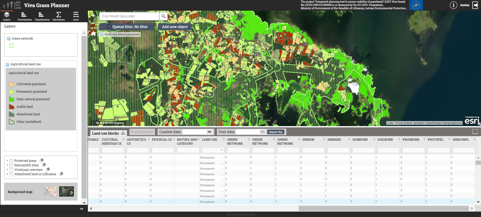
Visual analysis/assessment. Viva Grass Planner provides a wide range of map functionality: basemap selector, 3rd party data upload, zoom in/zoom out, location search, map layer management including possibility to change layer transparency, etc. All this enables the user to assess map data visually and to make spatial data based decisions.
Calculation. It is one of the most powerful tools in Viva Grass Planner. This simple to use tool enables the user to intersect land use blocks with a selected context data layer and to store this intersection result as attribute info in the land use block. For this DMS it is used to select land use blocks which intersect with protected species areas and conflict zones.
Classification. This functionality enables the user to classify land use blocks to different categories based on advanced selection expressions related to the land use block attribute information. For this DMS it will be used to classify grasslands which should be included into the GN.
Upload/Download. This is very important functionality of the Tool, because you can download the data you need in any step, you can modify it in other (eg. ArcGIS for Desktop) tools and upload it back to the Viva Grass Planner module.
Adding context data layers
Viva Grass Planner >> More >> Settings >> Layers settings
Turn on layers listed below by checking checkboxes.
Context data layer list:
Green network (polygons) – GN alternatives should be uploaded to this layer with a alternative identificator as attribute value.
Custom Polygon Layer (polygons) – General Plan polygons
Protected species (areas) (polygons) – number of protected species per sq km
Other context layers can be switched on or off if needed.
Important! To see changes user needs to reload Tool and login once again.
Adding custom attributes
Viva Grass Planner >> More >> Settings >> User attributes
Add additional, custom attributes for the Land use blocks. These attributes can be used to store additional data about land use blocks, to store calculation, intersection, classification or prioritization results, etc.
ua4
SNinGN
Double
ua5
SNinGN2
Double
ua6
HabBund
Double
ua7
SoilBund
Double
ua8
ProdBund
Double
ua9
ProtSpec
Double
ua10
IsInConfl
Double
For this DMS we will need:
SNinGN – custom attribute to store result of calculation. Grasslands in the first GN alternative.
SNinGN2 – custom attribute to store result of calculation. Grasslands in the second GN alternative.
HabBund – grasslands that belong to the habitat bundle.
SoilBund – grasslands that belong to the soil bundle.
ProdBund – grasslands that belong to the production bundle.
ProtSpec – grasslands intersecting with protected species areas.
IsInConfl – custom attribute to store result of an overlap calculation. The main purpose of the overlap calculation is to detect areas in the proposed GN scenarios that overlap designated planning areas (as indicated in the General Plan).
Other attributes can be added if needed.
Important! To see changes user needs to reload Tool and login once again.
Additional attribute calculation
Viva Grass >> Calculation
Attribute calculation can be done in ArcGIS for Desktop or in the Planner. This tool lets intersect two layers (land use blocks and selected org’s contextual layer), intersect with a defined buffer (around land use block), find land use blocks which are within org’s contextual data layer polygons and how much elements from org’s context data layer land use block contains.
Land use blocks IN Green network (“GN_1”)
In this step we identify land use blocks which intersects with green network (org’s context data layer “Custom polygons layer”) green network polygon (Attribute “Type” = “GN_1”) (same layer has green network as a Green network alternative). As the result we get list of land use blocks which are in Green network.
Calculation results can be checked by filtering attribute table data (SNINGN > 0):
Land use blocks IN alternative Green network (“GN_2”)
In this step we identify land use blocks which intersects with alternative green network (org’s context data layer “Custom polygons layer”). Alternative green network polygon is stored in the same layer as separate polygon (Attribute “Type” = “GN_2”).
As the result of intersection we get list of land use blocks which are in alternative Green network.
Land use blocks intersecting protected species areas
Follow the example above to calculate the protected species areas, which intersect with the land use blocks.
Important! Once the calculation is finished, GN related attributes are calculated and stored into the structure of the Viva Grass Planner database. Now these values, together with other land use block attributes, such as land use type, land use, land quality, slope, ES values, bundles, trade-offs, etc. can be used for classification, prioritization and visual analysis.
Green network evaluator
An important step of planning the Green Network is locating critical areas where valuable habitats are neither included in the County Green Network, nor in any protected area. Those valuable grasslands are at risk of degradation and subsequent loss of key ES and should therefore be prioritized when planning the Green Network. The Green Network evaluator allows to detect and locate these priority areas in the map.
Demo steps:
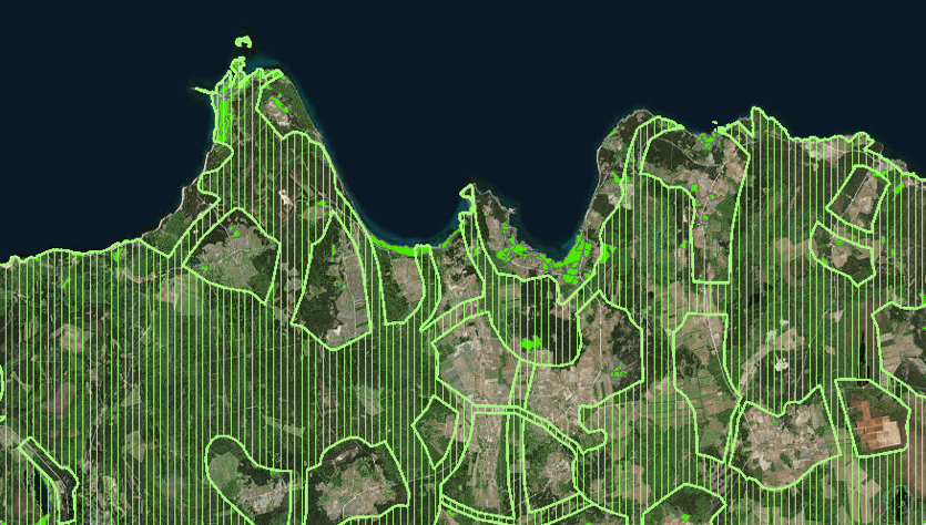
Visual analysis of the Green Network. As we have two alternative polygons in the same Green Network contextual data layer, we need to filter and leave only one Green network (Context data layer >> Attribute filter >> Type = GN_1)
As we are interested in valuable (semi-natural) grasslands left out of the county level Green network, first of all we need to filter all grasslands and leave only semi-natural. Land use blocks >> Attribute filter (“Land use” = Semi-natural grasslands)
Selecting valuable grasslands left outside of the green network. Land use blocks >> Attribute filter (“Land use” = Semi-natural grasslands AND “SNINGN” = 0 (land use blocks which are not in Green Network))
In order to visualize land use blocks in areas with protected species that are left outside of the Green Network: Land use blocks >> Attribute filter (“PROTSPEC” = 1 AND “SNINGN” = 0 (land use blocks which are not in Green Network))
Scenario builder (Classification)
Scenarios:
Scenario 1: Bare minimum (Grasslands belong to the Habitats Bundle)
Scenario 2: Medium ecological coherence (Grasslands belong to the Habitats Bundle and Grasslands intersect protected species areas)
Scenario 3: High ecological coherence (Grasslands belong to the Habitats Bundle and Grasslands intersect protected species areas and Grasslands belong to the Soils bundle). This represents the ideal scenario in terms of multiple ES delivery, and the highest possible degree of ES supply
In order to guide planners in the adoption of the County-level GN into the rural municipality General Plans, the prioritization DMS for Green Network proposes set of three predefined scenarios. The scenarios are understood as a gradually increasing (or decreasing) degree of inclusion and protection of grasslands in the GN. The criteria for the inclusion of semi-natural grasslands in the GN of rural municipality General Plan is based on their capacity to potentially deliver a certain set of ES. This capacity reaches a high level of multifunctionality when a certain grassland is part of an ecosystem services synergy (see section 1.2.2). In grasslands belonging to an ES synergy, the increase of the supply in one ES means an increase in the supply of more ES. In terms of the role of semi-natural grasslands inside the green network, the habitats synergy and the soils synergy offer a wide array of environmental benefits. These benefits (soil protection, pollination, etc.) are not only constrained to the grassland plot itself, but have a wider spatial effect (e.g. increased pollination benefits also surrounding agricultural land). By including grasslands belonging to ES synergies in the green network, we ensure the protection of regulating and maintenance ecosystem services, which are essential to preserve the overall coherence and functioning of the Green Network.
Demo steps:
Open classification Tool (Viva Grass Planner >> classification)
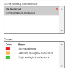
You can create a new classification rule by pressing “New classification” button or use and existing saved rule if you have one by selecting it from the “Select existing classification:” panel and pressing “Open”.
Opening classification. In this example we use the existing rule.
Editing or creating classes. You can edit the existing or create new classes within the rule. This is done by manually writing the expression and validating it by pressing the “Test” button.
Classification result appears in map layer list
Classification rules (stored in classification rule “GN scenarios”):
Class name
Expression
Comments
Bare minimum
ua6 = 1 AND ua9 = 0 AND ua7 = 0
Only grasslands belonging to the habitats bundle are included in scenario 1. These grasslands show a high delivery of habitat-related ecosystem services.
Medium ecological coherence
ua6 = 1 AND ua9 = 1 AND ua7 = 0
Grasslands in the habitats bundle and grasslands that contain protected species are included in this scenario 2.
High ecological coherence
ua6 = 1 AND ua9 = 1 AND ua7 = 1
Grasslands in the habitats bundle, grasslands in the soils bundle and grasslands that contain protected species are included in scenario 3. This represents the ideal scenario in terms of multiple eosystem services delivery, and the highest possible degree of ecosystem services supply.
Classification rules for the separate scenarios:
Bare minimum (Classification rule “Bare minimum”)
Class name
Expression
Comments
Bare minimum
ua6 = 1 AND ua9 = 0 AND ua7 = 0
Only grasslands belonging to the habitats bundle are included in scenario 1. These grasslands show a high delivery of habitat-related ecosystem services
Medium ecological coherence
Class name
Expression
Comments
Medium ecological coherence
ua6 = 1 AND ua9 = 1 AND ua7 = 0
Grasslands in the habitats bundle and grasslands that contain protected species are included in scenario 2.
High ecological coherence
Class name
Expression
Comments
High ecological coherence
ua6 = 1 AND ua9 = 1 AND ua7 = 1
Grasslands in the habitats bundle, grasslands in the soils bundle and grasslands that contain protected species are included in scenario 3. This represents the ideal scenario in terms of multiple ecosystem services delivery, and the highest possible degree of eocystem services supply.
Exploring the spatial location of valuable grasslands
The County-level Green Network acts as a guidance for Green Network planning at the municipality level. In this regard, it is necessary to explore the extent and type of grassland not included in the County GN. In many cases, the user will find large areas of valuable grasslands not included in protected areas or the County GN; these grasslands are at a higher risk of degradation.
Demo steps:
Filter only glasslands left out of the Green network (Attribute filter >> SNINGN = 0)
Open classification tool (Viva Grass Planner >> Classification)
Use spatial filter to define classification territory (for the demo purposes and for the faster calculation smaller territory could be used)
Select one of the scenarios from the stored classification rules list and press open.
Result shows on the map.
If needed classification rule can be edited: you can change expression, map visualization color, and new expression elements, etc.
To have all three scenarios these steps should be repeated and every time another classification rule should be selected.
Results:
Bare minimum.
Medium ecological coherence.
High ecological coherence.
Green Network evaluation (GN alternatives)
During the planning and consultation phase, a planner will consider several options or alternatives for inclusion of grasslands in the Green Network. It is useful to compare all options with the reference level set by the Green Network scenarios in terms of area and ecosystem services delivered. This tool allows the user to upload (see upload/download function in previous sections) different versions or designs of a GN and compare them visually in terms of valuable grasslands included under each design.
Demo steps:
Zoom in the map to better see differences of GN alternatives (use satellite basemap for the better visualization)
Two GN alternatives are stored in one “Green network” context data layer as two polygons with a different attribute values.
To see one or another polygon you need to open the context layer attribute list
And to filter the polygon you want to see on the map
As we used these GN polygons to calculate values (Custom attribute calculation, chapter above) we already have identification of which land use blocks/grasslands are in second Green Network alternative. We can use attribute filter and select grasslands which are not in GN2 (Land use blocks >> Attribute filter >> SNINGN2 = 0)
In this case, all the analysis steps described above should be applied for the grasslands left outside the GN2 alternative and then results can be compared.
Analysis of conflict between proposed grasslands and municipalities’ General Plans
Although the GN is inherently multifunctional, it is necessary to identify conflicts of interest in the design phase. Overlaps may potentially occur between the proposed grassland scenarios and already designated planning areas (e.g. industrial, residential). The Green Network DMS allows to detect conflicts between GN scenarios and general plans or any other potential source of conflict.
You can do this by turning on the “Custom polygon layer” which contains the already planned plots from the General Plan. Also by applying the classification and finding the most valuable grasslands to be included into the GN, you can then see where the conflicts arise. Certain decisions at these areas will have to be taken.
In the picture below you can see that the bright green area which is not in the GN is overlapped by plots planned in the General Plan. This means that there is a conflict between an already planned plot and the possibility to include these high ecological coherence grasslands into the GN.